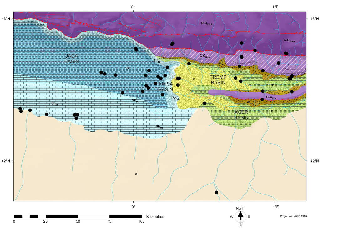
An Early Eocene paleogeographic map of the south central Pyrenees with geodynamics shown above contemporary base level and depositional environments and lithologies for areas below base level. Whilst lithological symbol sets are relatively consistent, there are no standard symbols for depositional environments. However, the use of blues for marine is common, and, perhaps surprisingly, the use of a yellow fill for delta tops. Part of the confusion when representing mapped depositional environments and systems, is the conflagration of depositional environments, gross depositional environments and facies.
|
The Knowing Earth Standard Legend for Paleogeography 2023 is designed to provide geologists with a standard symbol set to aid them in building paleogeographic maps. It covers all the key elements in the paleogeographic mapping workflow described in Markwick (2018). From crustal architecture, structural mapping, and geodynamics to depositional systems, drainage analysis, and landscape dynamics. The legend uses standard mapping symbology where these are well documented, such as structural elements and lithologies. For other parts of the workflow, the symbology is designed to make resulting maps as clear and intuitive as possible while simultaneously ensuring that multiple and diverse datasets can be superimposed to interrogate the system. The legend also includes graphical methods for representing mapping uncertainty. Although primarily designed for ESRI's ArcGIS software, the symbol set can be used with other software systems. This is an updated version of that provided as the supplementary data for Markwick (2018). |
|
Who is this designed for?
Anyone who is interested in mapping and understanding the Earth system.
Why?
By making this mapping legend publicly available, our aim is to help the scientific community get more from paleogeographic maps and, through this, better understand the Earth system.
We also hope that we can help provide some standardization in the map representation of paleogeographic and tectonic maps. Citation
If you need to cite this map legend please use my 2019 paper,
Markwick, P.J. 2019. Palaeogeography in exploration. Geological Magazine (London), 156, 366-407, https://doi.org/10.1017/S0016756818000468 |
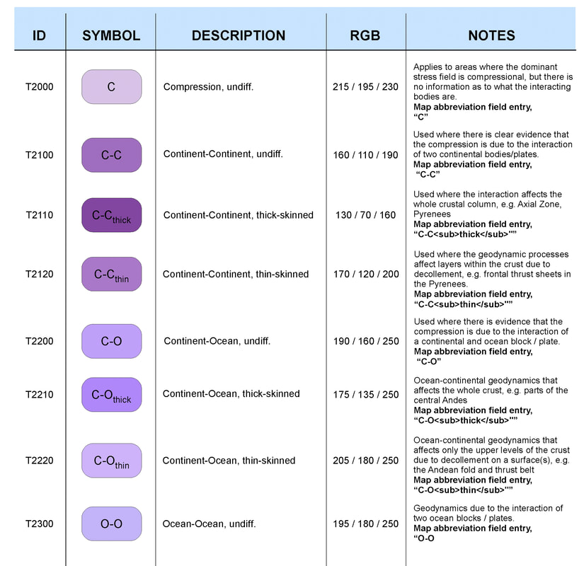
This example from the map legend shows the symbols for areas of compressional tectonics (Geodynamics Database)
|
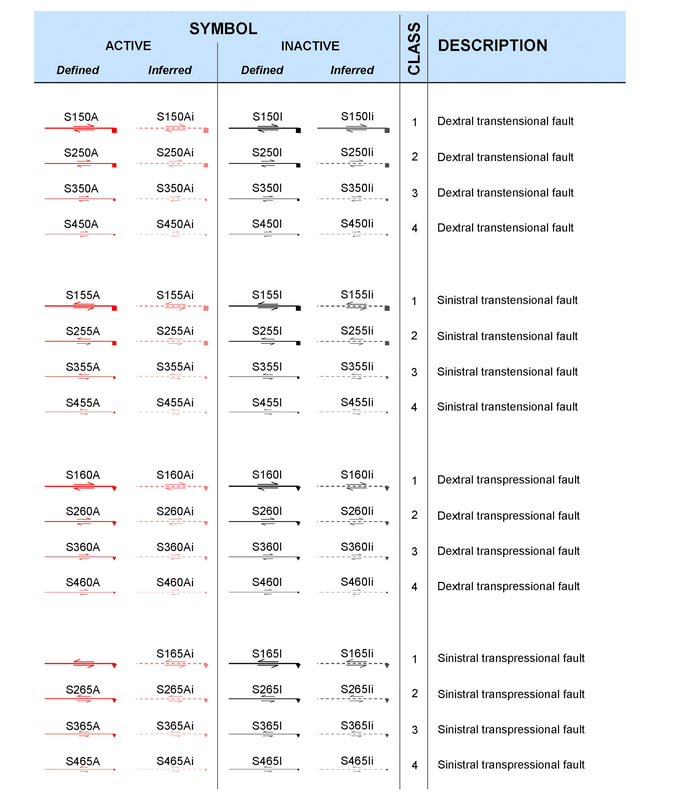
An example of the structural element symbol set from the Knowing Earth map legend. This example shows the symbols for transtensional and transpressional structures. The structural element symbol set follows published symbology where possible.
|
Direct Download
|
Two editions of our paleogeographic mapping legend are now available.
The .style file format is designed for use in ArcGIS Desktop and ArcGIS Pro. The accompanying explanation volume provides details on RGB codes and line formats so you can create your own versions in other software. |
2018 Edition
.style file with description (4MB) .style file with codes only (4.5MB) .zip file with 2018 edition style files (0.3MB) 2023 Edition
.style file with description (4.5MB) .style file with codes only (4.5MB) .zip file with 2018 edition style files (0.4MB) 2023 Edition
Explanation volume (public edition) (39MB) |
The style file with description is the best version to use if you want to manually select a symbol that matches your own needs.
The style file with codes only is the version to use if you want to automate symbolization and you use the same codes as our databases. |
|
Questions & Answers
Q. What is available?
A. You can freely download and use the .style files we have generated.
Q. How do I cite this map legend?
A. To cite this work, especially the symbologies for crustal facies, geodynamics, and depositional systems, which are new, please use my 2019 paper (Markwick 2019) – see reference list.
Q. Do you have other materials I can access for teaching?
A. Yes, check out our articles page and maps page. We also have other map symbol sets that we use internally. We are looking at how to make these available if there is demand.
Q. Is this the full suite of map symbolologies that you use?
A. This is only a subset of our full internal mapping legend, which also includes symbol sets for well and outcrop data, fossils and lithologies and climate, and paleoclimate model results. We use these internally and in our publications. However, we are looking at how to make these available in the next release of the map legend.
Q. Can I suggest changes or request new symbols?
A. Yes, if you have suggestions or requests for additional symbols, please get in touch with us at [email protected]
Q. How do I upload your .style file into ArcGIS?
A. If you are not sure how to upload the individual style files, you can find out how on this ESRI help page: https://desktop.arcgis.com/en/arcmap/latest/extensions/task-assistant-manager/importing-styles-from-a-style-file.htm
Related Publications
Markwick, P.J. 2019. Palaeogeography in exploration. Geological Magazine (London), 156, 366-407, https://doi.org/10.1017/S0016756818000468
Markwick, P.J., Paton, D.A. and Mortimer, E.J. 2021. Reclus: A new database for investigating the tectonics of the Earth: the East African margin and hinterland. Geochemistry, Geophysics, Geosystems, https://doi.org/10.1029/2021GC009897.
Markwick, P.J., Paton, D.A. and Mortimer, E.J. 2023. Mapping the complexity of Transform Margins. In: Nemčok, M., Doran, H., Doré, A.G., Ledvényiová, L. and Rybár, S. (eds) Tectonic development, thermal history and hydrocarbon habitat models of transform margins, and their differences from rifted margins. Geological Society, London, London, 524, https://doi.org/10.1144/SP524-2021-82.